State guide
Public land that may allow hunting in Maine
77 named public land units in Maine from PAD-US 4.1: 60 state wildlife & game areas, 2 forests & grasslands, 10 wildlife refuges & WPAs, 5 other public land units. The largest are White Mountain National Forest, Moosehorn National Wildlife Refuge, Sunkhaze Meadows National Wildlife Refuge.
- 77listed areas
- 195Kacres (approx.)
- 60state wildlife & game areas
Regulations & licenses: Maine Department of Inland Fisheries and Wildlife
This site does not list seasons, bag limits, license or permit rules. Those change every year and differ by area. Check them with the state agency before you go, and confirm the specific area is open to the hunting you plan.
Where the listed areas are
One dot per area at its reference point; larger dots are larger areas. Outline: U.S. Census Bureau.
Acres by land type
Approximate acres for the portion of each unit inside Maine.
Photos from Maine public lands
All photo credits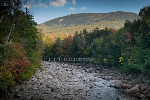
Photo: usfs_Eastern_Region · public domain · original source
Public-domain photos by U.S. federal agencies, taken in the place named on each card.
All 77 areas, largest first
- National Forest land
White Mountain National Forest
42,537 acres
U.S. Forest Service (USDA) · Oxford County
Open access - National Wildlife Refuge
Moosehorn National Wildlife Refuge
29,677 acres
U.S. Fish and Wildlife Service · Washington County
Restricted access - National Wildlife Refuge
Sunkhaze Meadows National Wildlife Refuge
11,582 acres
U.S. Fish and Wildlife Service · Penobscot County
Restricted access - National Wildlife Refuge
Umbagog National Wildlife Refuge
11,243 acres
U.S. Fish and Wildlife Service · Oxford County
Restricted access - State wildlife / game area
Mattawamkeag River Wildlife Management Area
9,996 acres
State: fish and wildlife agency · Penobscot County
Restricted access - National Forest land
White Mountain Purchase Unit
7,673 acres
U.S. Forest Service (USDA) · Oxford County
Open access - National Wildlife Refuge
Petit Manan National Wildlife Refuge
7,264 acres
U.S. Fish and Wildlife Service · Washington County, Hancock County + 2 more
Restricted access - State wildlife / game area
Bud Leavitt (Bull Hill) Wildlife Management Area
6,346 acres
State: fish and wildlife agency · Penobscot County, Piscataquis County
Restricted access - National Wildlife Refuge
Rachel Carson National Wildlife Refuge
5,792 acres
U.S. Fish and Wildlife Service · York County, Cumberland County
Restricted access - State wildlife / game area
Gene Letourneau (Frye Mountain) Wildlife Management Area
5,259 acres
State: fish and wildlife agency · Waldo County
Restricted access - State wildlife / game area
Vernon S. Walker Wildlife Management Area
5,228 acres
State: fish and wildlife agency · York County
Restricted access - National Wildlife Refuge
Aroostook National Wildlife Refuge
4,955 acres
U.S. Fish and Wildlife Service · Aroostook County
Restricted access - State wildlife / game area
Alonzo H. Garcelon Wildlife Management Area
4,950 acres
State: fish and wildlife agency · Kennebec County
Restricted access - State wildlife / game area
Plymouth Bog Wildlife Management Area
3,331 acres
State: fish and wildlife agency · Waldo County, Somerset County + 1 more
Restricted access - State wildlife / game area
Scarborough Marsh Wildlife Management Area
2,909 acres
State: fish and wildlife agency · Cumberland County, York County
Restricted access - State wildlife / game area
David Priest (Dwinal Pond) Wildlife Management Area
2,413 acres
State: fish and wildlife agency · Penobscot County
Restricted access - State wildlife / game area
Caribou Bog Wildlife Management Area
2,291 acres
State: fish and wildlife agency · Penobscot County
Restricted access - State wildlife / game area
Mt. Agamenticus Wildlife Management Area
2,276 acres
State: fish and wildlife agency · York County
Restricted access - State wildlife / game area
Killick Pond Wildlife Management Area
2,067 acres
State: fish and wildlife agency · York County
Restricted access - State wildlife / game area
Chesterville Wildlife Management Area
1,918 acres
State: fish and wildlife agency · Franklin County
Restricted access - State wildlife / game area
Cobscook Bay Wildlife Management Area
1,809 acres
State: fish and wildlife agency · Washington County
Restricted access - National Wildlife Refuge
Cross Island National Wildlife Refuge
1,728 acres
U.S. Fish and Wildlife Service · Washington County
Restricted access - State wildlife / game area
Pleasant Bay Wildlife Management Area
1,485 acres
State: fish and wildlife agency · Washington County
Restricted access - State wildlife / game area
Steve Powell (Swan Island) Wildlife Management Area
1,431 acres
State: fish and wildlife agency · Sagadahoc County
Restricted access - State wildlife / game area
Mattagodus Stream Wildlife Management Area
1,338 acres
State: fish and wildlife agency · Penobscot County
Restricted access - State wildlife / game area
Lyle Frost (Scammon Marsh) Wildlife Management Area
1,110 acres
State: fish and wildlife agency · Hancock County
Restricted access - State wildlife / game area
Merrymeeting Bay Wildlife Management Area
1,085 acres
State: fish and wildlife agency · Sagadahoc County
Restricted access - Waterfowl Production Area
Carlton Pond Waterfowl Production Area
1,040 acres
U.S. Fish and Wildlife Service · Waldo County
Restricted access - State wildlife / game area
Mount Agamenticus Wildlife Management Area
1,001 acres
State: fish and wildlife agency · York County
Restricted access - State wildlife / game area
Caribou Bog
925 acres
State: fish and wildlife agency · Penobscot County
Restricted access - State wildlife / game area
Jamies (Jimmie) Pond Wildlife Management Area
850 acres
State: fish and wildlife agency · Kennebec County
Restricted access - State wildlife / game area
Earle R. Kelly (Dresden Bog) Wildlife Management Area
845 acres
State: fish and wildlife agency · Lincoln County
Restricted access - State wildlife / game area
Fahi Pond Wildlife Management Area
751 acres
State: fish and wildlife agency · Somerset County
Restricted access - State wildlife / game area
R. Waldo Tyler (Weskeag Marsh) Wildlife Management Area
749 acres
State: fish and wildlife agency · Knox County
Restricted access - State wildlife / game area
Sawyer Mountian Highlands
718 acres
State: fish and wildlife agency · York County
Restricted access - State wildlife / game area
Booming Ground Wildlife Management Area
585 acres
State: fish and wildlife agency · Washington County
Restricted access - State wildlife / game area
Sandy Point Wildlife Management Area
570 acres
State: fish and wildlife agency · Waldo County
Restricted access - State wildlife / game area
Pollard Flat Wildlife Management Area
520 acres
State: fish and wildlife agency · Aroostook County
Restricted access - Other state land
Schoodic Bog
483 acres
State: department of conservation · Hancock County
Restricted access - State wildlife / game area
Mainstream Wildlife Management Area
483 acres
State: fish and wildlife agency · Somerset County
Restricted access - State wildlife / game area
Maj. Gregory Sanborn (Brownfield Bog) Wildlife Management Area
438 acres
State: fish and wildlife agency · Oxford County
Restricted access - Other state land
Maine Army National Guard Hollis Site
404 acres
State: other or unknown agency · York County
Open access - State wildlife / game area
Mount Agamenticus
340 acres
State: fish and wildlife agency · York County
Restricted access - State wildlife / game area
Spring River
316 acres
State: fish and wildlife agency · Hancock County
Restricted access - State wildlife / game area
Howard Mendall Wildlife Management Area
306 acres
State: fish and wildlife agency · Waldo County
Restricted access - State wildlife / game area
Little Ossipee River - Waterboro
291 acres
State: fish and wildlife agency · York County
Restricted access - State wildlife / game area
Green Point Wildlife Management Area
273 acres
State: fish and wildlife agency · Lincoln County
Restricted access - State wildlife / game area
Kennebec River Estuary Wildlife Management Area
248 acres
State: fish and wildlife agency · Sagadahoc County
Restricted access - State wildlife / game area
Tolla Wolla Wildlife Management Area
225 acres
State: fish and wildlife agency · Androscoggin County
Restricted access - State wildlife / game area
Morgan Meadow Wildlife Management Area
222 acres
State: fish and wildlife agency · Cumberland County
Restricted access - State wildlife / game area
Kennebunk Plains
192 acres
State: fish and wildlife agency · York County
Restricted access - State wildlife / game area
The Arm
157 acres
State: fish and wildlife agency · Washington County
Restricted access - State wildlife / game area
Lt. Gordon Manuel Wildlife Management Area
141 acres
State: fish and wildlife agency · Aroostook County
Restricted access - National Wildlife Refuge
Seal Island National Wildlife Refuge
125 acres
U.S. Fish and Wildlife Service · Knox County
Restricted access - State wildlife / game area
Spectacle Pond
121 acres
State: fish and wildlife agency · Kennebec County
Restricted access - State wildlife / game area
Narraguagus River
118 acres
State: fish and wildlife agency · Hancock County
Restricted access - Other state land
Maquoit Bay
116 acres
State: department of conservation · Cumberland County
Restricted access - State wildlife / game area
McKenney Estates Development
107 acres
State: fish and wildlife agency · Cumberland County
Restricted access - State wildlife / game area
Kep - Muddy River
104 acres
State: fish and wildlife agency · Sagadahoc County
Restricted access - State wildlife / game area
Kennebec Estuary
103 acres
State: fish and wildlife agency · Sagadahoc County
Restricted access - State wildlife / game area
Morgan Meadow
98 acres
State: fish and wildlife agency · Cumberland County
Restricted access - State wildlife / game area
Vernon Walker Wildlife Management Area
97 acres
State: fish and wildlife agency · York County
Restricted access - State wildlife / game area
Pleasant Bay - Pigeon Hill
96 acres
State: fish and wildlife agency · Washington County
Restricted access - State wildlife / game area
Lily Pond
91 acres
State: fish and wildlife agency · Cumberland County
Restricted access - State wildlife / game area
Ducktrap River Wildlife Management Area
80 acres
State: fish and wildlife agency · Waldo County
Restricted access - State wildlife / game area
Lyle Frost Wildlife Management Area
79 acres
State: fish and wildlife agency · Hancock County
Restricted access - State wildlife / game area
Pleasant Bay Wildlife Management Area - Sandy Cove Unit
73 acres
State: fish and wildlife agency · Washington County
Restricted access - State wildlife / game area
Kennebec Estuary - Chopps Creek Wildlife Management Area
72 acres
State: fish and wildlife agency · Sagadahoc County
Restricted access - Other state land
Whaleboat Island
63 acres
State: department of conservation · Cumberland County
Restricted access - State wildlife / game area
Kennebunk Plains Wildlife Management Area
55 acres
State: fish and wildlife agency · York County
Restricted access - State wildlife / game area
Jonesboro Wildlife Management Area
52 acres
State: fish and wildlife agency · Washington County
Restricted access - State wildlife / game area
Hurds Pond Wildlife Management Area
49 acres
State: fish and wildlife agency · Waldo County
Restricted access - National Wildlife Refuge
Great Thicket National Wildlife Refuge
48 acres
U.S. Fish and Wildlife Service · York County
Restricted access - State wildlife / game area
Alan E. Hutchinson Wildlife Management Area
43 acres
State: fish and wildlife agency
Restricted access - State wildlife / game area
Sherman Marsh Wildlife Wildlife Management Area
41 acres
State: fish and wildlife agency · Lincoln County
Restricted access - State wildlife / game area
Piscataquis River Access - Medford
40 acres
State: fish and wildlife agency · Piscataquis County
Restricted access
Acreage is calculated from simplified PAD-US boundaries for the portion inside Maine. “Access” is the PAD-US public access field, not a statement about hunting. National wildlife refuges are generally coded “restricted” in PAD-US because of seasonal or area closures.